Fishing today is better than ever. Anglers have a huge assortment of fishing gear to choose from, and with apps like Fishbrain, the savvy Angler can also get a wealth of data about the environment around them. One of the most time-tested methods of finding the right fish within a body of water is depth and contour maps, which can be found within the app.
With a depth map, you can see how deep the lake or body of water you’re fishing in is, and spot the shallow areas. Combined with contour lines, you can get a great picture of how the floor of the water looks. How steeply it declines, and more.
How to Read Contour Lines
The contour lines within a depth map allow you to easily visualize changes in depth. You can look at the spacing between each line to understand how shallow or deep the area you’re fishing in is. By looking at the distance between the lines, you can determine where the steepness may be more pronounced.
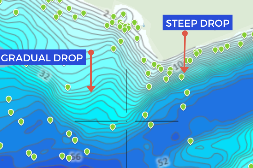
For example, if you see lines spaced very close to together, this indicates a steep transition, which means the water gets deeper very quickly and within very little distance. If you have ever heard someone mention a “drop off” when discussing fishing, they are referring to these points.
Here is an example of what a steep transition looks like, using Fishbrain’s depth maps:

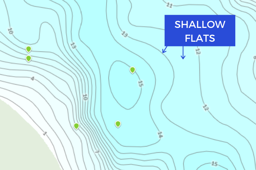
On the other hand, when you see lines that are spaced widely apart, these indicate very slow includes and more gradual transitions. These areas are often referred to as “flats” when fishing.
Here is an example of what a shallow or flat area of fishing may look like:

How to Find Fish with a Lake Contour Map
Now that you understand the basics of a depth and contour map, you can use this information to better predict where fish will be. You can even use this to target certain species of fish. The behavior of the fish is often closely related to what the underground structure of the water looks like. Taking this into account, along with other important factors that affect fish behavior such as light, weather, temperature, and food sources, you can accurately pinpoint where to cast your line.
Let’s say you are fishing in the early spring and want to target bass. Using this information, you’ll want to seek out shallow areas (like in the second picture) containing weeds and other vegetation.
Alternatively, if you were searching for Crappie in the summer months, you might want to search for an area that looks more like the first picture. You want to find deep basins along steep drop-offs. Alternatively, you can look at flats and find sunken items such as logs where fish may like to hide.
Using Depth Maps & Contour Lines to your Advantage
Now that you understand how depth maps work. Take some time to study Fishbrain’s maps prior to hitting the water. With some knowledge of the species, their migration patterns, and what the structure of the water looks like, you will be able to find fishing hot spots in no time.


